28 August 2010

Thesis has been done, but the work continues

Fellow friend sent me this link on The Good, The Bad, and the Ugly. Great discussion on how people view vacancy from a neighborhood, developer, and financial viewpoint.

the vid itself, while long - goes through what I researched during the spring. The neighborhood is Flatbush, BK which is directly south of Crown Heights and carries a similar proportion of vacancies around.


Please wait while the video loads.


04 June 2010

FRANKLIN AVENUE, CROWN HEIGHTS, BK: a blighted snapshot


fig. 16 
Detail of Crown Heights and Franklin Avenue site (adapted by the author)    

Crown Heights is a diverse neighborhood that occupies the central portion of the New York City borough of Brooklyn. Approximately two square miles, the community lies northeast of Prospect Park and is situated next to neighborhoods Prospect Heights (west), Bedford Stuyvesant (north), and Flatbush (south), and Brownsville (east). Eastern Parkway is the main thoroughfare, which spans east-west through its center. Two commercial districts, Nostrand Avenue and Franklin Avenue [fig. 16], are situated north-south.

    The area began as a high-end residential neighborhood for the city’s elite in the early 1900s. Demographically, the neighborhood has diversified economically and ethnically from the 1930s to the present. Nearly forty percent of the neighborhood population is first generation immigrants11. Residents from the Caribbean, Eastern European Jews, and African Americans all call Crown Heights home. 

    In the 1970s, the energy crisis, inflation, and rising operating expenses sent New York City into extreme financial decline. Suburban flight left many neighborhoods, such as those along Eastern Parkway, with vacant buildings. Moreover, the quality of life waned with underperforming schools and excess housing stock. Widespread arson swept across Brooklyn and the South Bronx, initiated by landlords seeking claims from insurance proceeds12.
 
    Franklin Avenue is a survivor of that period. During the 1970s and 1980s, rampant robberies forced banks and small businesses to relocate to a safer area. Extensive crime and violence made residents fearful to be outside while forcing businesses to close early. Tony Fisher, long-time owner of Fisher Supermarkets on Franklin Avenue, described the street being so dangerous in the 1980s, that one had to “duck and run”13.  Consequently, more than half of the corridor’s sixty-six storefronts moved due to the ongoing violence14.
 
    The 1990s saw a decrease of crime throughout New York City as gentrification and urban renewal spread. Local grassroots organizations like the CPC (Community Preservation Corporation) and the CHCA (Crow Hill Community Association) have helped to reverse the trend of decline. Since 1999, the CHCA has focused on rehabilitating the half-mile stretch of Franklin Avenue between Atlantic Avenue and Eastern Parkway. When the project began, the street had a total of 90 local storefronts, with a one-third of them vacant. By 2003, 108 storefronts were operating and only 17 were vacant15.


Table 1    
Franklin Ave. Survey between Atlantic Ave. and Eastern Parkway, Brooklyn, NY (conducted November 2009 by author)

    The Franklin Avenue thoroughfare has since become a magnet for attracting young professionals, college graduates, and artists. Affordable rent and easy access to mass transit offer an alternative to the higher priced neighboring communities – Prospect Heights and Park Slope – within Brooklyn. Recent business and restaurant openings offer alternatives to the many bodegas and salons on the street. Unfortunately, the 2007 recession has slowed down construction and development along Franklin. New openings have become less frequent. As a result, vacancy and blight still continue to plague the corridor in the three typologies outlined earlier [fig. 17]. Over twenty percent of the street corridor now remains vacant [Table 1].    

11 Cissner, Amanda B. and Amy Ellenbogen. “Op Data, 2003: Crown Heights, Brooklyn: Community Assessment and Perceptions of quality of Life, Safety, Services”, 1. Available from Center for Court Innovation.

12 “CPC’s 30 Year Investment in Brooklyn’s Eastern Parkway Corridor Neighborhoods Result in Thriving Communities”. Available from the Community Preservation Corporation.

13  Warren, Matthew. “Two Coffeehouses mean competition in Crown Heights”. New York Times, 22 November 2009. <http://www.nytimes.com/2009/11/23/nyregion/23coffee.html>.

14 “Listen To This: Crown Heights Oral History Project: A Visit from Evangeline”. Available from Crown Heights Oral History Project: <http://crownheightshistoryproject.blogspot.com/2010/02/visit-from-evangeline.html>.

15 “Crow Hill Community Association: History”. Available from Crow Hill Community Association: <http://www.crowhillcommunity.org/history.shtml>.

03 June 2010

Resolving Vacancy: promoting urban vitality

Challenges remain for redeveloping vacant land. Community and city based organizations often attack the source with singular approaches. Instead, a more comprehensive approach should address a strategy to implement, while balancing the social, political, and environmental ramifications. In most cases, the main goal of city officials is to work for the community’s interests and well being. 

    Bowman and Pagano list three imperatives that influence cities’ decisions within the U.S. federal system:
 
    1.    the need to enhance the city’s fiscal state;
    2.    the need to limit social disruption and protect property values;
    3.    the need to maintain and enhance the community image6.
 
However, their actions are determined by other constraints both internal and external to city affairs. Actions on vacant properties are influenced by the context and setting. Cities can use vacancy to generate revenue, define communities, or enhance existing conditions.
 
    Cities may treat vacant land as a tax generating property. However, some developments may generate more revenue than others. For instance, a commercial storefront selling higher priced goods like jewelry may produce more tax revenue than a coffee shop. Maximizing revenue for the city, the “land-tax dynamic”, thus becomes a key strategy in deciding any vacancy outcome7.
 
    Vacant lots also serve as social indicators of defining neighborhoods – separating areas along income and class lines. Acting as social buffers, vacancy can protect property values by allowing groups to cluster together. Such is the case with New York City’s Central Park and its border properties8. City policy may dictate vacancy as planned parks, open space, or transportation corridors9. Therefore, the social makeup resulting from a city intervention should factor in any changes made.
 
    Finally, the act of developing vacant properties can improve a city’s image. Cities may appropriate public funds for generating economic activity – either through subsidization for developers, improved infrastructure, or other public works related projects that would encourage additional development. Chicago’s opening of Millennium Park resulted from the development of a downtown blighted eyesore - the transformation of exposed railroad tracks into a multifunctional public park. Its construction enhanced the city by providing additional public space, while drawing additional tourist traffic to its downtown lakefront with world-class architecture and art. The economic effects are both immediate - an improved streetscape - and long term – providing the opportunity to compete economically with other cities10.
 
    Overall, a city’s reaction to vacancy will address a combination of the three imperatives mentioned above – allowing for a sound fiscal position, providing social stability for its neighborhoods, and developing economic viability. 

6 Bowman, Ann O’M and Michael A. Pagano. “Vacant Land in Cities: An Urban Resource”. (The Brookings Institution, December 2000), 35.

7 Bowman, Ann O’M and Michael A. Pagano. “Vacant Land in Cities: An Urban Resource”. (The Brookings Institution, December 2000), 40-41.

8 Harden, Blaine. “Neighbors Give Central Park A Wealthy Glow”. New York Times, 22 November 1999.

9 Bowman, Ann O’M and Michael A. Pagano. “Vacant Land in Cities: An Urban Resource”. (The Brookings Institution, December 2000), 44.

10 Bowman, Ann O’M and Michael A. Pagano. “Vacant Land in Cities: An Urban Resource”. (The Brookings Institution, December 2000), 44-45.

Rethinking Vacancy

Vacant land litters American cities like the trash strewn along their streets. It could be a foreclosed home, or the empty business storefront. Perhaps it is the overgrown corner lot, filled with litter, or a future site awaiting development. In their many guises, they reside in rural, industrial, or urban settings. “Vacant” is the label used to describe these abandoned properties. Often, these properties, underutilized land within the built city, challenge a community with the task of trying to incorporate them into its well-being. 

    Although the scope of this phenomenon is nationwide, cities rarely have a central department that tracks their location. According to the Brookings Institute, vacant and abandoned properties account for 15 percent of the area of the typical large city, more than 12,000 acres on average1. Can they present the opportunity to be a resource, reprogrammed into the urban system? Large metropolitan cities such as Detroit, Michigan and Philadelphia, Pennsylvania have taken such steps to combat blight. 

    The term “vacant lot” conjures up negative images. It frequently is described as decaying, derelict, empty, or dangerous. These undesirable conditions result in its description as an “urban wasteland”:

[A] place may be considered derelict to the extent that the symbols of disinvestment, vacancy, and degradation dominate. Where disrepair, litter, emptiness, violation, and other signs of diminished habitat prevail, a derelict zone exists in mind if not reality2. As a result, decaying structures leave harmful impressions of deterioration. 


fig. 15
The Contagion Effect of Vacant Land: The Impact of Vacant Lots on Surrounding Properties
(source: Fairmont Ventures, Inc. “Vacant Land Management In Philadelphia Neighborhoods: Cost Benefit Analysis,” report prepared for the Pennsylvania Horticultural Society (PHS), April 1999. Reprinted by permission of PHS.

    Moreover, vacancy portends future abandonment through its spread by contagion. In the book, Terra Incognita, Bowman and Pagano use a declining commercial district as an example to describe this contagion effect3  [fig. 15]. First, store closings may result in less retail traffic, which can endanger remaining businesses. Less business threatens its economic viability and increases the rate of vacancy. Second, storefronts become boarded up, reinforcing a canyon of shuttered windows along a commercial corridor. Lastly, decreased maintenance of these structures may result in demolition, leaving permanent voids that become “dead space”. 

    What remains is a blighted area, stained by bleak, isolated lots lined with chain link and barbed wire. A study conducted by the Eastern Pennsylvania Organizing Project and the Temple University Center for Public Policy states that “estimates of the impact of abandonment on property values in a neighborhood provide a basis to project potential benefits from renovating abandoned properties4”. Properties closer to vacancies “had lower prices…than properties located farther from abandoned properties5”.

    Reasons vary for this perpetual cycle.  Many properties may have been abandoned for years. At some point, a landlord may decide that a rental property is too expensive to keep up and further decline follows. As a result, this decay and abandonment deters potential buyers or renters. A study conducted in Philadelphia, Pa. found that a vacant lot dampened the value of eight nearby properties [fig 3]. Moreover, multiple vacancies on a block can blight entire stretches of a street with undesirable effects.  

    Although most people perceive vacant land as a negative needing correction, can vacant land offer opportunity? Can available space become a resource, not a detractor?

    After the Great Chicago Fire of 1871, much of the city’s ruinous rubble was dumped into Lake Michigan providing more vacant land for the city to grow. Similar stories of American cities filling in wetlands or shorelines were crucial to their initial growth. A growing city can view vacancy as an asset for development. Moreover, these available resources can be used to promote a planned vision.

    Three typologies, that this paper will investigate, track the cycle of a property’s development: the abandoned lot, the construction site, and the empty storefront or building. The abandoned lot is a cleared parcel that waits to be infilled by a program or structure. Properties that are under construction may be considered buildings under development or renovation. Empty buildings or storefronts are, typically, spaces temporarily unoccupied. All three types above address the cyclical nature of a given property’s life.

1 Bowman, Ann O’M and Michael A. Pagano. “Vacant Land in Cities: An Urban Resource”. (The Brookings Institution, December 2000), 1.

2 Jakle, John A. and David Wilson. Derelict Landscapes: The Wasting of America’s Built Environment (Savage, MD: Rowman & Littlefield, 1992), 9.

3 Bowman, Ann O’M and Michael A. Pagano. “Vacant Land in Cities: An Urban Resource”. (The Brookings Institution, December 2000), 2.

4 Gordon Whitman, Anne Shlay, Steve Honeyman, and Roy Diamond. “Blight Free Philadelphia: A Public-Private Strategy to Create and Enhance Neighborhood Value”. (Philadelphia, PA:  Temple University Center for Public Policy and Eastern Pennsylvania Organizing Project, with assistance from Diamond & Associates, 2001), 20.

5 Gordon Whitman, Anne Shlay, Steve Honeyman, and Roy Diamond. “Blight Free Philadelphia: A Public-Private Strategy to Create and Enhance Neighborhood Value”. (Philadelphia, PA:  Temple University Center for Public Policy and Eastern Pennsylvania Organizing Project, with assistance from Diamond & Associates, 2001), 21.

02 June 2010

A Neighborhood Transformed

What happens when a neighborhood is in a state of decline? Cities such as Pittsburgh, Pennsylvania, and Detroit, Michigan, have become empty shells of their former glory after industry left them behind. Prolonged vacancies result in neighborhoods that are no longer self-sustaining, filled with empty lots and abandoned buildings. 


fig. 9 and 10
The Heidelberg Project, Detroit, MI (Photos by Debra Jane Seltzer)

    The Heidelberg Project began in 1986 by Tyree Guyton in Detroit’s East Side neighborhood. It is an example of artworks that spark dialogue between vacancy and the community. Together with his grandfather, Guyton began cleaning up lots along Heidelberg and Elba streets in an area perceived as dangerous and unwelcoming. Guyton salvaged random material and transformed it into art installations, turning the neighborhood landscape into large art environments through the decoration of abandoned houses and yards6 [fig 9 and 10]. The art has empowered the neighborhood, instilling it with pride. It now welcomes 275,000 annual visitors to walk the streets at all times of day7

    The neighborhood provides a social critique of the blight and decay within the neighborhood and the city as whole. Twenty-four houses serve as inspiration to date, posing questions on the definition of community and the bonds that make a city work. On two occasions in the 1990s, the city of Detroit demolished a total of six houses in the Heidelberg Project, citing their existence as an impediment to urban planning. As a result, Guyton and supporters filed a civil lawsuit. The Wayne County circuit court ruled in their favor to protect the artist’s 1st amendment rights.  


fig. 11
Kea Tawana Ark, Newark, NJ (Photo by Camilo Jose Vergara)

    In a similar project, Kea Tawana built a wooden ark on city vacant land in Newark, New Jersey in 1981 [fig. 11]. Fed up with city neglect of the neighborhood since the 1967 riots, Tawana decided to create a massive structure – ninety feet wide and three stories high – using scavenged material. The ark served to provide hope and symbolize renewal. Unfortunately, the city decided to raze the structure, stating that its presence did not comply with code.

    All of these art environments respond to the social condition left by vacancy and address neglect by enlivening an abandoned lot or derelict building. They present playful and composed installations. Opinions of these creations vary between curiosity or intolerance. People living in the immediate area may be intolerant of the artistic squatting on the condemned property, and city intervention may coincide with neighborhood opposition through the introduction of city codes and regulations8.  


fig. 12
Evening view of the Heidelberg Project, Detroit, MI (Photo by Mike Budziak)


    One problem with the Heidelberg Project is that in the evening, the works recede back into their environment [fig. 12]. Street fixtures turn on, and the area visually reverts back to their status quo. The Heidelberg Project’s large-scale installations become monstrosities that scatter the landscape like the refuse found in a vacant lot. In addition, the low color rendering index (CRI) of the high-pressure sodium lighting washes everything in a sickly yellow [fig 13 and 14], eliminating the vibrant colors painted by Guyton on these projects. Either taken as individual works or a whole environment, the failure to highlight these art transformations reduces the vital uniqueness on display.  


fig. 13 and 14
Evening view of the Heidelberg Project, Detroit, MI (Photos by Mike Budziak)


    To provide the works with special lighting might allow the Heidelberg Project to continue its discourse. This can be accomplished with temporary fixtures strategically placed onsite to create dramatic effect. By using a lamp with a higher CRI than HPS, these scenes would contrast from the streetscape and better display the vacant condition. The creation of spectacle is not the intent. Instead, the light provides a vehicle to support the social commentary of the artist author.

6 Guyton, Tyree. Connecting the Dots: Tyree Guyton’s Heidelberg Project. (Detroit: Wayne State University Press, 2007), 1.

7 “Heidelberg Project”. Available from Wikipedia: <http://en.wikipedia.org/wiki/Heidelberg_Project> (accessed 1 February 2010).

8 Brown, Chip. “Tawana’s Ark”, New York Magazine, 6 April 1987, 22.

Best Pedestrian Route

Scaffolding is often seen as utilitarian, functional structures in the United States. These sidewalk sheds serve to protect pedestrians from construction on a building or site, while workers are hoisting materials up and down. Formally, they consist of sheet steel propped on steel tube frames, with plywood and mesh walls lining their structure [fig. 4]. Lighting is often provided overhead with single lamp fixtures that dot the underside of these sheds.  As a whole, their role does little to compliment or enhance the construction site. On the other hand, these barriers visually signal the arrival of planned change.


fig. 4    Scaffolding structure canopy detail (Photo by author)

   William Mitchell, former dean of the School of Architecture and Planning at MIT, observes that scaffolding in Europe and Japan are sensitive to the visual disturbance they impose on the built environment3. Moreover, European and Japanese architects and engineers understand the visual disturbance that these structures create on the urban streetscape. Recent commissions and competitions in the United States have followed their lead and brought to light how scaffolding can be reimagined. In 1998 Michael Graves designed the scaffolding for the Washington Monument renovation on D.C.’s National Mall [fig.5]. Thirty-seven miles of scaffolding surrounded the monument, while fabric draped over it mimicked the masonry of the obelisk. Its presence transformed the monument and mall when it was lit at night. Some admirers of the monument scaffolding even petitioned for it to remain after work was complete. The question remains: how does scaffolding integrate within a construction site in a manner that balances aesthetics with function?


fig. 5    Washington Memorial renovation 1998, Washington, D.C. (Photos by Alex Wong. Courtesy of Getty Images.)

    The Alliance of Downtown New York has been working to enhance the quality of life in Lower Manhattan since 1995. Initiated in 2007, Re:Construction is a public art program that allows artists and designers to use construction sites as blank slates for public art installations. The project reimagines construction barriers with thoughtful, unusual designs. Together with the artist and developers, the Downtown Alliance works to enhance lower Manhattan with creative alternatives to the standard barricades4.


fig. 6 Best Pedestrian Route, New York, NY (Photos courtesy of Shift Boston)

    Among the works installed, GRO Architects addressed sidewalk scaffolding with Best Pedestrian Route (2007)5. By taking visual cues from Jersey barriers and construction signs, angled plywood struts artfully compose a scaffolding structure. The arrayed angles hint at the volatility occurring behind the structure. In addition, arrow-shaped apertures provide views for pedestrians to see the construction progress occurring [fig. 6]. The project succeeds by working with various scales and meanings. Graphic cues borrow elements from standard signage.  The orange color warns of construction, while the arrows allow site illumination to provide sidewalk lighting. The arrow composition claims the pedestrian’s attention, not providing instructive use, but signalling the construction activity behind. The use of bright colors and unique access of light to the walkway provides a stimulating contrast to the standard scaffolding along normal city sidewalks.  Best Pedestrian Route is meant to be modular, allowing for multiple structures to line any given site.


fig. 7 and 8   
Urban Umbrella, New York, NY (Photos courtesy of UrbanSHED International Design Competition)


    Another example of the reimagined scaffold, which has been promised funding and construction by the Alliance, is the UrbanShed design competition. In 2009, the New York Buildings Department and the AIA New York Chapter launched a competition for the design of city scaffold sheds. The winning design Urban Umbrella by University of Pennsylvania architecture student Young-Hwan Choi took structural cues from an umbrella. The metal structure uses curved tubing to hold and support translucent fiberglass panels. The intent is to draw natural light into the shed during the day [fig. 7], while LED strip lighting provides evening illumination [fig. 8]. The proposal succeeds by providing additional natural light to flow underneath the shed structures. The placement of the LED strips playfully corresponds to the vaulted supports beneath the panels. Moreover, the removal of cross bracing allows pedestrians to freely walk between the metal braces and provides for better visibility of the building and store facade.
 
    Both of these examples offer structural and aesthetic alternatives to the common shed. A building may undergo construction indefinitely, yet these sheds provide an attractive option to the pedestrian and street environment.
 
    In reality, the options outlined above may be costly to implement. Best Pedestrian Route’s usage of custom-shaped apertures lacks the advantage of easy production. Sourcing custom CNC-milled sheets from a manufacturing vendor adds another layer to the production time. Time could be used more effectively with simple modifications that allow for 4’ x 8’ plywood sheets to be modified onsite.
 
    The Urban Umbrella maintains it is equivalent in cost to the current scaffolding shed. Its response attempts to beautify the surrounding building. While the scaffolding treatment allows for views of building storefronts, Urban Umbrella does not address scaffolding that walls off construction sites from the activity in progress. Further explorations with that application would strengthen its design intent. Together, Best Pedestrian Route and Urban Umbrella could be synthesized to create a viable option that is aesthetic and functional.

3 Escobar, Gabriel. “Obelisk’s Scaffold Is First of Its Kind.” Available from Washington Post, 30 December, 1998. <http://www.washingtonpost.com/wp-srv/local/longterm/library/monument/monument.htm>.

4 “Downtown Alliance: Re:Construction”. Available from: Downtown Alliance.

5 “Best Pedestrian Route by GRO Architects”. Available from ShiftBoston, 9 August 2009.

Signage for Storefronts

The ongoing recession of 2007 has closed down many businesses. Consequently, many commercial storefronts have emptied their spaces with landlords seeking tenants to fill them on a temporary basis. Brooklyn developer Jed Walentas of Two Trees Development states, “Any sort of activity is better than no activity1.” One solution seeks out advertisers to bring their messages to street level. As a result, these storefronts generate revenue and temporarily provide a different form of merchandising. Vinyl coverings act as pedestrian billboards, adhering to windows and building facades [fig. 1].


fig. 1: A Nestea ad in the window of a vacant store in New York. (Photo by InWindow Outdoor. Courtesy of the New York Times)

    Ad placement on storefronts heightens brand awareness to pedestrians, while allowing commercial occupation of the space. Monster Media, a leader in storefront advertising, worked with MTV to bring awareness of their new show, “The Buried Life”, to the public2. Placed in busy midtown Manhattan, the ads engage pedestrians asking, “What do you want to do before you die?” Strangers can enter their responses on an interactive interface, where their responses can then be displayed on the one of the building windows [fig. 2].


fig. 2: MTV The Buried Life, 521 5th Ave, NY, NY (Photos courtesy of Ads of the World)

   Interactive storefront advertisers like Monster Media and InWindow provides different transactions between product and potential consumers. Text messages or holograms become tools to exchange information along a sidewalk. Vacant stores, once an eyesore, maintain the selling of products through ad marketing.  

    The opportunity to utilize light as an agent to reinforce a property’s commercial function suggests other options. Lighting certain aspects of the interior space can promote the space potential. Looking through the window, eyes would be drawn into the space, imagining its possibilities.

    Three storefronts for rent in Midtown Manhattan utilize light to promote their commercial attractiveness. One storefront retains the space decorated by the former tenant, while the others sit empty with white walls. “PRIME RETAIL SPACE FOR RENT” and slick architectural renderings front the windows, beckoning potential tenants to imagine their new business location [fig. 3].


fig. 3: Midtown Manhattan retail space (Photos by author)

 All three are lit differently. The unchanged space uses fluorescent-lit troffers. The space is carpeted with painted walls in a natural color palette. Its appearance resembles an office: a drop down ceiling, lit with lensed ceiling troffers typical of corporate America. Ceramic metal halide ceiling fixtures light the second space. The space is barren with white walls. Its light reminds one of factory floors and warehouses. The last storefront appears to be a former lobby foyer that has been walled off by painted white drywall. The space is lit with a utility strip of two 8’ T12 fluorescents. The strip has been mounted vertically, centered on the backwall.

    Regardless of their “For Rent” signage, the spaces draw in sidewalk glances by remaining lit throughout the day. For instance, the vertical, wall mounted fluorescent attracts attention due to its unusual placement. Its emanating glow within a barren space provokes questions of why it is lit and what is its significance. The barren walls and exposed wiring further suggests an empty canvas awaiting to be changed.

    The painted walls and troffers in the other storefront recall the space’s former identity. It echoes the possibility to remain in status quo. Despite this, the space does little to promote its future without the computer rendering placed in front of window. As a group, elements of the three storefronts work together to reimagine possible scenarios for business space types.  

18 April 2010

CASE STUDIES

How do communities address blight and change its perception from negative to positive? Vacancy does not determine abandonment. Yet, communities are attempting to circumvent its negative effects by implementing unique solutions. Three case studies investigate each of the vacancy typologies outlined - 1) vacant lots, 2) construction sites, and 3) abandoned buildings/storefronts. In all circumstances, they address filling in that empty void with a meaningful element to spark dialogue and engage the surroundings meaningfully. Their success or failure depends on the social and environmental transformation fulfilled through implementation.

ABSTRACT

Vacant properties are a national occurrence. The phenomenon produces consequences that include stressed municipalities and blight. My position is that lighting can reclaim a deteriorating public environment by securing a vacant site throughout different stages within its development cycle.

    Franklin Avenue – a mixed use street caught in the economic downturn - in North Crown Heights, Brooklyn, New York, contains three vacancy typologies:

1. THE ABANDONED LOT
   cleared parcels that await to be infilled by a program or structure

2. THE CONSTRUCTION SITE
   buildings under development or renovation

3. THE EMPTY BUILDING/STOREFRONT
   spaces temporarily unoccupied

 All three typologies address the cyclical nature of a given property’s life. The application of light on blight re-examines temporal permanence and questions its future, unknown manifestation. Its treatment shifts perceptions from a neglected property to a space of positive opportunity. Light informs and transforms, while mending the urban fabric.

    Rather than promoting the gentrification of a neighborhood, the aim of this project is to initiate a dialogue on vacancy within an urban setting. Light helps us discover what Dolores Hayden has called “the power of ordinary urban landscapes to nurture citizens’ public memory, to encompass shared time in the form of shared territory(1).”

      The site’s twelve blocks divide into four zones. With timed controls, each zone will light intermittently over a 15-minute period at the start of each hour after dusk. Drama unfolds as vacancies briefly reveal their potential and then return to their current status quo. As an exploration with a sequence of illuminated planes, light highlights a neighborhood’s forgotten past and its positive future, thereby exposing a property’s changing role in a community.

1 Hayden, Dolores. The Power of Place: Urban Landscapes as Public History.  (Cambridge, MIT Press, 1995), 9.

25 January 2010

Sparkle for the new semester

Spring semester officially begins today. Progress posts will be forthcoming.

Cheers to some sparkle was found on the barbed wire around one of the lots on Sterling and Franklin.


06 January 2010

The Chicago Underpass

Over break, I have begun searching my hometown for methods that communities may combat blight. Underpasses are often neglected. Urine smells, stains, garbage, and pigeon droppings often litter these spaces. Of recent, moves have been made to counter their banality. For instance, while some may see a salt stain, the religious faithful see Mary  - in a white shroud - beneath the Fullerton viaduct underneath the I-94 Kennedy Expressway. Since 2005, believers have sustained a homemade shrine adorning the wall with religious imagery and flowers. Day and night, followers come by the site to enliven this wall.


The Bryn Mawr and Foster viaducts beneath Lake Shore Drive commissioned the Chicago Public Art Group to create murals depicting the neighborhood history. These mosaic murals use brightly colored tiles and some mirror like pieces to catch passers attention. Pedestrians and bikers may find this friendly but a driver may find a glare bomb awaiting on a sunny day. High Pressure Sodium lights currently disservice these murals at night, rendering them yellow. Yet the intent to use these walls as community gates provide a welcome gesture for the cars and people entering.


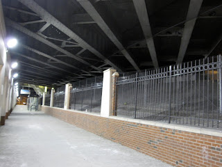
Lastly, a third area looks at the Irving Park viaduct beneath the Kennedy Expressway. CDOT has lit the area and double fenced it to deter vagrants from taking shelter. Chain link is used inside, while wrought iron and brick "nicens" the intent. A brightly lit sidewalk and dual fencing protects the pedestrian from the dark recesses.

I begin to ask the basic questions for these interventions: who made it, who should be attracted/deterred, and why is something lit in a certain way? In conclusion, vacancies can be treated as an invitation or barrier that can shape one's experience of passage.

05 January 2010

815 FRANKLIN AVENUE at Eastern Parkway


 Construction has been off and on again over the past 2 years at this site. Since October, viewing windows have been installed allowing pedestrians see the "progress" being made outside the subway station. 


Eli Mazon, states that he plans to build a large: mixed-use project including condominium apartments and retail space on the first floor.

Tax class: all others
Tax block/lot: 1259/1
Lot frontage: 98 feet
Lot depth: 123 feet
Irregularly shaped lot: yes
Building frontage: feet
Building depth: 123
Irregularly shaped building: no
Zoning codes from NYC Department of City Planning: R7-1

785 FRANKLIN AVENUE


My favorite jamaican jerk was served here but closed down right after thanksgiving.

Tax class: apartments with 7-10 units
Tax block/lot: 1252/9
Number of units (condos, etc). in the building: 7
Number of residential units (condos, etc). in the building: 5
Lot frontage: 27 feet
Lot depth: 90 feet
Irregularly shaped lot: no
Building frontage: 27 feet
Building depth: 90 feet
Irregularly shaped building: no
The number of stories for the building: 3
The number of buildings on the property: 1
The year the building was built: 1931
Zoning codes from NYC Department of City Planning: R6

781 FRANKLIN AVE


Name awaits change.

Tax class: apartments with 4-6 units
Tax block/lot: 1252/10
Number of units (condos, etc). in the building: 6
Number of residential units (condos, etc). in the building: 5
Lot frontage: 27 feet
Lot depth: 90 feet
Irregularly shaped lot: no
Building frontage: 27 feet
Building depth: 90 feet
Irregularly shaped building: no
The number of stories for the building: 3
The number of buildings on the property: 1
The year the building was built: 1931
Zoning codes from NYC Department of City Planning: R6

766 FRANKLIN AVENUE

 
Tax class: apartments with 4-6 units
Tax block/lot: 1178/44
Number of units (condos, etc). in the building: 5
Number of residential units (condos, etc). in the building: 4
Lot frontage: 20 feet
Lot depth: 100 feet
Irregularly shaped lot: yes
Building frontage: 20 feet
Building depth: 100 feet
Irregularly shaped building: no
Additional: garage
The number of stories for the building: 3
The number of buildings on the property: 1
The year the building was built: 1915
Zoning codes from NYC Department of City Planning: R7-1 


The storefront here is destined to become Dutch Boy Burgers, opened by Franklin Park's Matt Roff. The blue tarp went down last month leaving a kraft papered windowfront in view.

Happy 2010

Cheers to the holiday season and here's to hoping that 2010 will open opportunities for all. In many cases, one wonders whether vacancies contribute to blight or are just opportunities that have yet to be realized. My social objective - to create cohesive spaces that would promote community interaction along the avenue in the evening. Stay tuned.